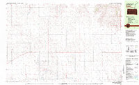
1981 Map of Patricia
USGS Topo · Published 1981About this map
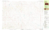
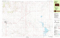
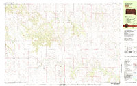
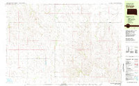
Bear-in-the-Lodge Creek winds through the heart of this Bennett County landscape, defining the drainage patterns that shaped local settlement during the early 1980s. The small community of Patricia anchors the eastern edge of the survey, while the settlement of Black Eyes is situated to the southwest near the creek's lower reaches. This map illustrates a transition between the water-rich drainages of Red Horse Creek and Pretty Hip Creek and the industrial activity found at the Gravel Pits. The presence of numerous wells and isolated buildings suggests a scattered ranching or agricultural economy typical of this South Dakota region. To the southeast, the shoreline of White Lake appears at the quadrangle boundary, providing a terminal point for the seasonal flows of Spring Creek.
Find a feature on this map
9 named features on this map. Tap any name to fly to it.
Don’t see what you’re looking for? This feature index may not catch every label — zoom into the map to look around manually.
Map Details
Editions of this 1981 Patricia Map
This is the sole edition of this map. No revisions or reprints were ever made.
Other maps of this area

1955 · Martin
USGS Topo · 1:250,000

1958 · Martin
USGS Topo · 1:250,000

1981 · Long Valley
USGS Topo · 1:25,000
1981 · Martin
USGS Topo · 1:25,000
1981 · Allen
USGS Topo · 1:25,000
1981 · Blackpipe
USGS Topo · 1:25,000

1981 · Hisle
USGS Topo · 1:25,000
1981 · Swett
USGS Topo · 1:25,000

1981 · Buzzard Butte
USGS Topo · 1:25,000
1981 · Tuthill
USGS Topo · 1:25,000