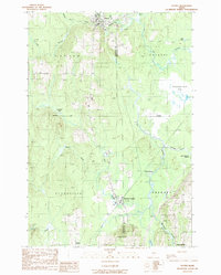
1989 Map of Patten
USGS Topo · Published 1989About this map
Patten anchors this northern Maine landscape at the transition between Penobscot and Aroostook counties. The settlement pattern follows the drainages of Fish Stream and the Molunkus Stream, with concentrated hubs at Sherman Station and Sherman Mills. A surveyor’s Monument Line cuts west to east across the terrain, marking a formal boundary through dense wetlands like Blackwell Bog and the expansive Thousand Acre Bog. Evidence of the region’s timber and transport history is visible in the network of rail-aligned points such as Patten Junction. While much of the land is defined by water and forest, local industry is marked by scattered Gravel Pits and the uniquely named settlement of Siberia in the southwestern corner near Torrie Brook.
Find a feature on this map
35 named features on this map. Tap any name to fly to it.
Don’t see what you’re looking for? This feature index may not catch every label — zoom into the map to look around manually.
Map Details
Editions of this 1989 Patten Map
This is the sole edition of this map. No revisions or reprints were ever made.
Other maps of this area

1940 · Island Falls
USGS Topo · 1:62,500

1940 · Sherman
USGS Topo · 1:62,500

1942 · Island Falls
USGS Topo · 1:62,500

1942 · Sherman
USGS Topo · 1:62,500

1953 · Stacyville
USGS Topo · 1:62,500

1954 · Shin Pond
USGS Topo · 1:62,500

1954 · Presque Isle
USGS Topo · 1:250,000

1954 · Millinocket
USGS Topo · 1:250,000

1958 · Presque Isle
USGS Topo · 1:250,000

1958 · Millinocket
USGS Topo · 1:250,000