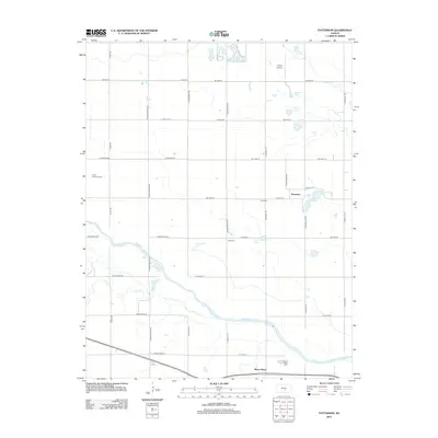
2012 Map of Patterson
USGS Topo · Published 2012About this map
The Arkansas River winds through the southern portion of this Kansas landscape, defining the rural geography between the small settlements of Patterson and Mount Hope. This 2012 survey illustrates a classic prairie section-line grid, where roads like S Rayl Rd and S Sand Hill Rd partition the agricultural fields. The terrain is dotted with small bodies of water, including Patterson Lake, Greenfield Lake, and the cluster of Boyle Lakes and Saucer Lake to the north, suggesting the subtle drainage patterns of the low-lying river valley.
Find a feature on this map
43 named features on this map. Tap any name to fly to it.
Don’t see what you’re looking for? This feature index may not catch every label — zoom into the map to look around manually.
Map Details
Editions of this 2012 Patterson Map
This is the sole edition of this map. No revisions or reprints were ever made.
Other maps of this area

1889 · Cheney
USGS Topo · 1:125,000

1891 · Hutchinson
USGS Topo · 1:125,000

1891 · Cheney
USGS Topo · 1:125,000

1893 · Hutchinson
USGS Topo · 1:125,000

1901 · Cheney
USGS Topo · 1:125,000

1955 · Wichita
USGS Topo · 1:250,000

1955 · Hutchinson
USGS Topo · 1:250,000

1958 · Wichita
USGS Topo · 1:250,000

1958 · Patterson
USGS Topo · 1:24,000
1958 · Bentley
USGS Topo · 1:24,000