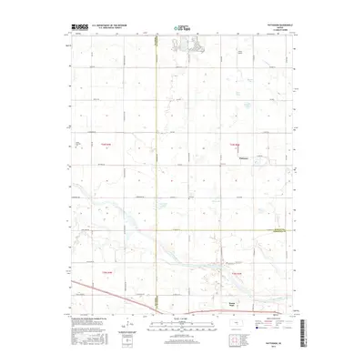
2015 Map of Patterson
USGS Topo · Published 2015About this map
The Arkansas River winds through the southern reaches of this landscape, defining the boundary between Harvey and Sedgwick counties. Near its banks, the community of Mount Hope serves as a local anchor, while the smaller settlement of Patterson is situated to the north, adjacent to the waters of Patterson Lake. This region is characterized by a high density of small water bodies and wetlands, including Meadow Lake, Boyle Lakes, Saucer Lake, and Greenfield Lake, which punctuate the agricultural grid. Genealogical and local history points of interest are well-distributed across the quadrangle, notably Valley Township Cem in the west, Hunt Cem near Patterson, and Star Cem centrally located. The presence of Fisher Airport in the northeast quadrant highlights the local aviation infrastructure within this prairie-river environment.
Find a feature on this map
57 named features on this map. Tap any name to fly to it.
Don’t see what you’re looking for? This feature index may not catch every label — zoom into the map to look around manually.
Map Details
Editions of this 2015 Patterson Map
This is the sole edition of this map. No revisions or reprints were ever made.
Other maps of this area

1889 · Cheney
USGS Topo · 1:125,000

1891 · Hutchinson
USGS Topo · 1:125,000

1891 · Cheney
USGS Topo · 1:125,000

1893 · Hutchinson
USGS Topo · 1:125,000

1901 · Cheney
USGS Topo · 1:125,000

1955 · Wichita
USGS Topo · 1:250,000

1955 · Hutchinson
USGS Topo · 1:250,000

1958 · Wichita
USGS Topo · 1:250,000

1958 · Patterson
USGS Topo · 1:24,000
1958 · Bentley
USGS Topo · 1:24,000