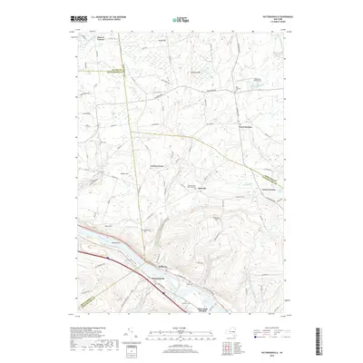
2019 Map of Pattersonville
USGS Topo · Published 2019About this map
The Mohawk River carves through this Mohawk Valley landscape, shaping the development of riverside communities like Pattersonville and Rotterdam Junction. This 2019 survey captures the varied topography from the river flats near Swart-Island to the rising elevations of Glenville Hill and Dennison Hill. The area's agricultural and rural heritage is evident in the numerous family and community burial grounds scattered across the terrain, including Woestina Cem, Vedder Cem, and the West Glenville Reformed Cem. Small crossroads settlements like West Charlton, Green Corners, and Beyers Corners define the upland sections, connected by a network of local roads such as Sacandaga Rd and Western Ave. The presence of Westwind Farm Airport and Iwan Airfield reflects modern land use, while numerous kills and creeks, such as the Alplaus Kill and Chaughtanoonda Creek, trace the natural drainage patterns that have long influenced settlement in Schenectady and Saratoga counties.
Find a feature on this map
99 named features on this map. Tap any name to fly to it.
Don’t see what you’re looking for? This feature index may not catch every label — zoom into the map to look around manually.
Map Details
Editions of this 2019 Pattersonville Map
This is the sole edition of this map. No revisions or reprints were ever made.
Other maps of this area

1893 · Schenectady
USGS Topo · 1:62,500

1895 · Schenectady
USGS Topo · 1:62,500

1895 · Amsterdam
USGS Topo · 1:62,500

1898 · Schenectady
USGS Topo · 1:62,500

1899 · Broadalbin
USGS Topo · 1:62,500

1902 · Broadalbin
USGS Topo · 1:62,500

1902 · Saratoga
USGS Topo · 1:62,500

1930 · Schenectady
USGS Topo · 1:62,500

1931 · Amsterdam
USGS Topo · 1:62,500

1935 · Middle Grove
USGS Topo · 1:24,000