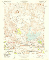
1953 Map of Paulsell
USGS Topo · Published 1955About this map
The Sierra Railroad winds through the hills of eastern Stanislaus County, connecting the small settlement of Paulsell to the broader regional economy during the early 1950s. This agricultural and hydraulic landscape is defined by an intricate network of irrigation works, including the Modesto Main Canal and the Turlock Main Canal, which draw from the Tuolumne River in the south. The dominant water feature is the Dallas Warner Reservoir, its sprawling irregular shoreline filling the central basins between dry ridges. Local transport depends on a mix of established routes like Warnerville Road and Tim Bell Road, alongside specialized infrastructure such as the Paulsell Lateral. The presence of numerous siphons and water tanks throughout the survey area illustrates the intensive management of water required to sustain the valley's cattle and farming operations in this transition zone between the river bottom and the foothills.
Find a feature on this map
22 named features on this map. Tap any name to fly to it.
Don’t see what you’re looking for? This feature index may not catch every label — zoom into the map to look around manually.
Map Details
Editions of this 1953 Paulsell Map
This is the sole edition of this map. No revisions or reprints were ever made.
Other maps of this area

1913 · Dickenson
USGS Topo · 1:31,680

1915 · Oakdale
USGS Topo · 1:31,680

1915 · Paulsell
USGS Topo · 1:31,680

1916 · Three Tree Flat
USGS Topo · 1:31,680

1916 · Montpellier
USGS Topo · 1:31,680

1916 · Cooperstown
USGS Topo · 1:31,680

1916 · Denair
USGS Topo · 1:31,680

1916 · Waterford
USGS Topo · 1:31,680

1916 · Copperopolis
USGS Topo · 1:62,500

1939 · Modesto East
USGS Topo · 1:62,500