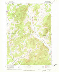
1967 Map of Pawlet
USGS Topo · Published 1972About this map
Mettawee River valley life in the late 1960s is defined by the tight connection between the rugged slate-producing hills and the winding waterway. The village of Pawlet serves as a primary hub, situated where Flower Brook joins the main river channel, while the smaller settlements of North Rupert, East Rupert, and Rupert line the southern valley floor. This survey reveals an active extraction landscape, with multiple Quarries and Quarry sites dotting the northern slopes near Indian Hill.
Find a feature on this map
39 named features on this map. Tap any name to fly to it.
Don’t see what you’re looking for? This feature index may not catch every label — zoom into the map to look around manually.
Map Details
Editions of this 1967 Pawlet Map
This is the sole edition of this map. No revisions or reprints were ever made.
Other maps of this area

1893 · Fort Ann
USGS Topo · 1:62,500

1894 · Pawlet
USGS Topo · 1:62,500

1894 · Equinox
USGS Topo · 1:62,500

1895 · Cambridge
USGS Topo · 1:62,500

1895 · Fort Ann
USGS Topo · 1:62,500

1896 · Equinox
USGS Topo · 1:62,500

1897 · Pawlet
USGS Topo · 1:62,500

1898 · Cambridge
USGS Topo · 1:62,500

1898 · Fort Ann
USGS Topo · 1:62,500

1900 · Equinox
USGS Topo · 1:62,500