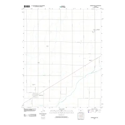
2009 Map of Pawnee Rock
USGS Topo · Published 2009About this map
Pawnee Rock stands as a focal point along the southwestern rail corridor in this survey of Barton County. The settlement patterns here follow a strict grid of section roads, including SW 100 Ave and SW 50 Rd, which define the agricultural landscape of the Great Plains. Cultural and genealogical history is preserved in several rural burial grounds such as Rockville Cemetery, Bergtal Cemetery, and the Pawnee Rock Cemetery located north of the primary townsite. The Arkansas River cuts across the southeastern portion of the quadrangle, paralleled by the rail line through the community of Dundee. This survey highlights the intersection of historic river travel and modern aviation, with the Great Bend Municipal Airport positioned in the northeastern corner. The drainage of Ash Creek further shapes the southern terrain, illustrating the relationship between water sources and the development of these prairie communities.
Find a feature on this map
24 named features on this map. Tap any name to fly to it.
Don’t see what you’re looking for? This feature index may not catch every label — zoom into the map to look around manually.
Map Details
Editions of this 2009 Pawnee Rock Map
This is the sole edition of this map. No revisions or reprints were ever made.
Other maps of this area

1889 · Larned
USGS Topo · 1:125,000

1891 · Great Bend
USGS Topo · 1:125,000

1891 · Larned
USGS Topo · 1:125,000

1893 · Great Bend
USGS Topo · 1:125,000

1955 · Great Bend
USGS Topo · 1:250,000

1957 · Great Bend
USGS Topo · 1:250,000

1958 · Great Bend
USGS Topo · 1:250,000

1958 · Great Bend
USGS Topo · 1:24,000

1959 · Great Bend NE
USGS Topo · 1:24,000

1960 · Pawnee Rock
USGS Topo · 1:24,000