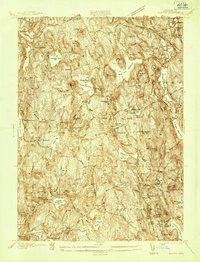
1937 Map of Paxton
USGS Topo · Published 1937About this map
Paxton Center and its surrounding highlands anchor this pre-war survey of central Massachusetts, a landscape defined by its glacial hills and an extensive network of water resources. In the north, the Veterans Hospital and Rutland Center overlook a terrain marked by numerous summits, including the prominent Asnebumskit Hill. Industrial history is evident in the Spencer area, where Upper Wire Village and Lower Wire Village sit along the drainage of Sevenmile R, pointing to the region's manufacturing legacy. The transportation corridor of the Boston and Maine RR cuts across the northwest corner near West Rutland. This era shows a community balanced between rural utility and growing recreation, seen in the shoreline development at Turkey Hill Shores and several reservoirs like Lynde Brook Reservoir and the Holden Reservoirs that serve the neighboring urban centers.
Find a feature on this map
84 named features on this map. Tap any name to fly to it.
Don’t see what you’re looking for? This feature index may not catch every label — zoom into the map to look around manually.
Map Details
Editions of this 1937 Paxton Map
This is the sole edition of this map. No revisions or reprints were ever made.
Other maps of this area

1885 · Worcester
USGS Topo · 1:62,500

1886 · Worcester
USGS Topo · 1:62,500

1887 · Brookfield
USGS Topo · 1:62,500

1887 · Barre
USGS Topo · 1:62,500

1889 · Webster
USGS Topo · 1:62,500

1889 · Barre
USGS Topo · 1:62,500

1890 · Brookfield
USGS Topo · 1:62,500

1892 · Webster
USGS Topo · 1:62,500

1892 · Worcester
USGS Topo · 1:62,500

1893 · Brookfield
USGS Topo · 1:62,500