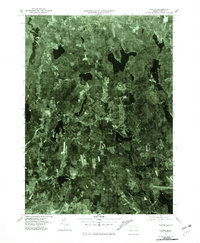
1975 Map of Paxton
USGS Topo · Published 1981About this map
Paxton and its surrounding woodlands are captured here via high-altitude aerial photography, offering a distinct overhead view of central Massachusetts in the mid-1970s. The landscape is defined by its numerous glacial water bodies and the emerging suburban patterns connecting Rutland to the northwestern reaches of Worcester. Small clusters of development at Sibleys Corner and Jefferson contrast with the dense forest cover, illustrating the region's character as a transition between rural highland and industrial center. This orthophotograph, rectified from 1975 imagery, provides a clear visual record of land use before the expansion of modern infrastructure, showing the exact footprint of settlements like Spencer and recreational landmarks such as Sandy Beach.
Find a feature on this map
7 named features on this map. Tap any name to fly to it.
Don’t see what you’re looking for? This feature index may not catch every label — zoom into the map to look around manually.
Map Details
Editions of this 1975 Paxton Map
This is the sole edition of this map. No revisions or reprints were ever made.
Other maps of this area

1885 · Worcester
USGS Topo · 1:62,500

1886 · Worcester
USGS Topo · 1:62,500

1887 · Brookfield
USGS Topo · 1:62,500

1887 · Barre
USGS Topo · 1:62,500

1889 · Webster
USGS Topo · 1:62,500

1889 · Barre
USGS Topo · 1:62,500

1890 · Brookfield
USGS Topo · 1:62,500

1892 · Webster
USGS Topo · 1:62,500

1892 · Worcester
USGS Topo · 1:62,500

1893 · Brookfield
USGS Topo · 1:62,500