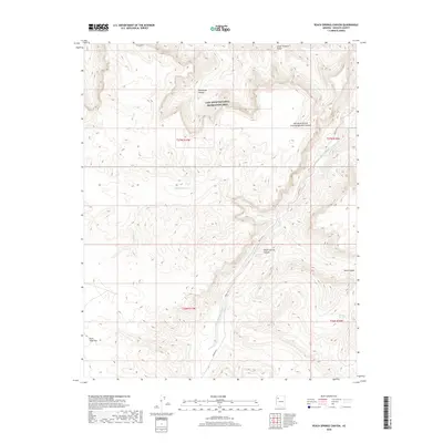
2018 Map of Peach Springs Canyon
USGS Topo · Published 2018About this map
Peach Springs Canyon dominates this landscape in Mohave County, where the topography transitions from the dramatic depths of the Lower Granite Gorge toward the higher plateaus of northwestern Arizona. The terrain is defined by a complex network of drainage systems, including the uniquely named Two Hundred and Twentyeightmile Canyon and the seasonal path of Peach Springs Wash. These canyons serve as the primary geographical features within this section of the Lake Mead National Recreation Area. For those studying the hydrology of the region, the location of remote water sources like Mesquite Spring and Metuck Springs provides insight into the scarce water resources available across the arid Plain Tank Flat and through the steep descent of Hells Canyon.
Find a feature on this map
16 named features on this map. Tap any name to fly to it.
Don’t see what you’re looking for? This feature index may not catch every label — zoom into the map to look around manually.
Map Details
Editions of this 2018 Peach Springs Canyon Map
This is the sole edition of this map. No revisions or reprints were ever made.
Other maps of this area

1886 · Diamond Creek
USGS Topo · 1:250,000

1892 · Diamond Creek
USGS Topo · 1:250,000

1948 · Williams
USGS Topo · 1:250,000

1954 · Williams
USGS Topo · 1:250,000

1956 · Williams
USGS Topo · 1:250,000

1960 · Williams
USGS Topo · 1:250,000

1961 · Williams
USGS Topo · 1:250,000
1967 · Milkweed Canyon SE
USGS Topo · 1:24,000

1967 · Peach Springs
USGS Topo · 1:24,000
1967 · Travertine Rapids
USGS Topo · 1:24,000