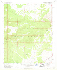
1967 Map of Milkweed Canyon SE
USGS Topo · Published 1969About this map
The Hualapai Indian Reservation dominates this 1967 survey, encompassing the high-elevation terrain of the Music Mountains and the flatlands of Plain Tank. This arid landscape is defined by its essential water infrastructure, including Horse Trough Spring and a series of livestock tanks like Box Canyon Tank and Trail Tank. These features highlight the importance of water management for ranching and resource use on the reservation during the mid-20th century.
Find a feature on this map
18 named features on this map. Tap any name to fly to it.
Don’t see what you’re looking for? This feature index may not catch every label — zoom into the map to look around manually.
Map Details
Editions of this 1967 Milkweed Canyon SE Map
2 editions found
Other maps of this area

1886 · Diamond Creek
USGS Topo · 1:250,000

1892 · Diamond Creek
USGS Topo · 1:250,000

1948 · Williams
USGS Topo · 1:250,000

1954 · Williams
USGS Topo · 1:250,000

1956 · Williams
USGS Topo · 1:250,000

1960 · Williams
USGS Topo · 1:250,000

1961 · Williams
USGS Topo · 1:250,000

1967 · Milkweed Canyon SW
USGS Topo · 1:24,000

1967 · Peach Springs
USGS Topo · 1:24,000
1967 · Milkweed Canyon NW
USGS Topo · 1:24,000