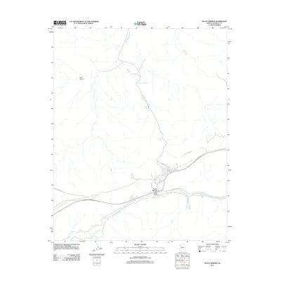
2011 Map of Peach Springs
USGS Topo · Published 2011About this map
Peach Springs serves as the primary hub of this high-desert landscape in Mohave County, positioned where the drainage of Peach Springs Wash and Truxton Wash converge. The topography is defined by significant water sources and deep incisions like Box Canyon, which have historically dictated the placement of roads and settlements in this arid region. The town is anchored by the Peach Springs Post Office, with residential life concentrated along Wahanda Way and Honaga Rd. The map reveals a transition from these clustered developments to the open, rugged surroundings marked by named desert seeps, including Mulberry Spring, Red Spring, and Lower Peach Springs. This layout illustrates a community deeply integrated with the natural hydrography, where tribal routes such as Indian Rte 6 and Indian Rte 19 trace the contours of the dry washes.
Find a feature on this map
18 named features on this map. Tap any name to fly to it.
Don’t see what you’re looking for? This feature index may not catch every label — zoom into the map to look around manually.
Map Details
Editions of this 2011 Peach Springs Map
This is the sole edition of this map. No revisions or reprints were ever made.
Other maps of this area

1886 · Diamond Creek
USGS Topo · 1:250,000

1892 · Diamond Creek
USGS Topo · 1:250,000

1948 · Williams
USGS Topo · 1:250,000

1954 · Williams
USGS Topo · 1:250,000

1956 · Williams
USGS Topo · 1:250,000

1960 · Williams
USGS Topo · 1:250,000

1961 · Williams
USGS Topo · 1:250,000
1967 · Milkweed Canyon SE
USGS Topo · 1:24,000

1967 · Peach Springs
USGS Topo · 1:24,000
1967 · Peach Springs Canyon
USGS Topo · 1:24,000