1935 Map of Peachtree
USGS Topo · Published 1935About this map
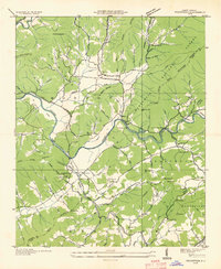
The Hiwassee River winds through this 1935 survey of the border between Cherokee and Clay counties, documenting a landscape at the intersection of traditional Appalachian life and modernizing infrastructure. Central to the social history of the area is the John C Campbell Folk Sch near Brasstown, established only a decade before this field examination to preserve local craftsmanship and community education. The landscape is dotted with small congregations and educational outposts such as Sally Nebo Ch, Little Brasstown Ch, and the Sweetwater Sch, illustrating the dispersed settlement patterns of the mountain coves.
Find a feature on this map
98 named features on this map. Tap any name to fly to it.
Don’t see what you’re looking for? This feature index may not catch every label — zoom into the map to look around manually.
Map Details
Editions of this 1935 Peachtree Map
This is the sole edition of this map. No revisions or reprints were ever made.
Other maps of this area

1886 · Dahlonega
USGS Topo · 1:125,000

1888 · Ellijay
USGS Topo · 1:125,000

1892 · Dahlonega
USGS Topo · 1:125,000

1892 · Ellijay
USGS Topo · 1:125,000

1893 · Murphy
USGS Topo · 1:125,000

1896 · Dahlonega
USGS Topo · 1:125,000

1898 · Ellijay
USGS Topo · 1:125,000

1903 · Dahlonega
USGS Topo · 1:125,000

1911 · Ellijay
USGS Topo · 1:125,000

1914 · Murphy
USGS Topo · 1:125,000