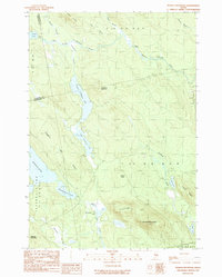
1990 Map of Peaked Mountain
USGS Topo · Published 1990About this map
Peaked Mountain dominates the southern landscape of this 1990 Washington County interior, marking a topographic high point in a region defined by complex glacial water systems and commercial timberlands. The hydrology of the area is centered on the chain of Lower Cranberry Lake and Upper Cranberry Lake, which drain northward via Cranberry Stream toward the West Branch Machias River. To the west, the expansive Mopang Lake and Mopang Second Lake illustrate the interconnected nature of the Maine North Woods drainage basins.
Find a feature on this map
32 named features on this map. Tap any name to fly to it.
Don’t see what you’re looking for? This feature index may not catch every label — zoom into the map to look around manually.
Map Details
Editions of this 1990 Peaked Mountain Map
This is the sole edition of this map. No revisions or reprints were ever made.
Other maps of this area

1929 · Lead Mountain
USGS Topo · 1:48,000

1932 · Nicatous Lake
USGS Topo · 1:48,000

1932 · Lead Mountain
USGS Topo · 1:62,500

1934 · Nicatous Lake
USGS Topo · 1:62,500

1941 · Tug Mountain
USGS Topo · 1:62,500

1941 · Wabassus Lake
USGS Topo · 1:62,500

1943 · Tug Mountain
USGS Topo · 1:62,500

1943 · Wabassus Lake
USGS Topo · 1:62,500

1948 · Bangor
USGS Topo · 1:250,000

1953 · Wabassus Lake
USGS Topo · 1:62,500