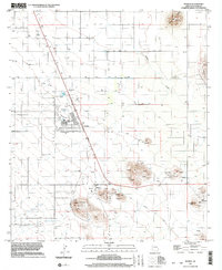
1996 Map of Pearce
USGS Topo · Published 2002About this map
Pearce and the planned community of Sunsites define the desert floor of the Sulphur Springs Valley in this late-twentieth-century study. While the newer grid of Sunsites includes a Golf Course and several Mobile Home Park areas, the map also captures the region's deeper industrial roots. The landscape is punctuated by the remains of extractive operations, from the Mine Shafts and Tailings Pond near Pearce Hill to various Prospect and Adit markers scattered across the terrain. An Old Railroad Grade traces a path through the valley, marking the legacy of the rail-and-mine economy that once dominated the area. Prominent topographical features like Three Sisters Buttes and Sixmile Hill provide sharp relief against the basin, where a Communication Tower and Sewage Disposal Ponds represent the modern infrastructure supporting these desert settlements.
Find a feature on this map
21 named features on this map. Tap any name to fly to it.
Don’t see what you’re looking for? This feature index may not catch every label — zoom into the map to look around manually.
Map Details
Editions of this 1996 Pearce Map
This is the sole edition of this map. No revisions or reprints were ever made.
Other maps of this area

1916 · Pearce
USGS Topo · 1:125,000

1922 · Willcox
USGS Topo · 1:125,000

1926 · Light
USGS Topo · 1:62,500

1926 · Courtland
USGS Topo · 1:62,500

1943 · Dos Cabezas
USGS Topo · 1:62,500

1943 · Cochise
USGS Topo · 1:62,500

1954 · Silver City
USGS Topo · 1:250,000

1955 · Douglas
USGS Topo · 1:250,000

1957 · Dos Cabezas
USGS Topo · 1:62,500

1958 · Silver City
USGS Topo · 1:250,000