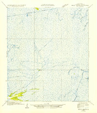
1954 Map of Pecan Island NE
USGS Topo · Published 1954About this map
Front Ridge and a network of land-elevations punctuate the vast coastal marsh of Vermilion Parish in this 1954 publication based on 1930s field examinations. The landscape is defined by its traditional waterborne transportation routes, most notably the several branches of the Pirogue Trail that snake through the wetlands between Lost Island and Belle Isle. This survey captures the region's hydrography before modern extensive drainage projects, showing the original course of the Old Intracoastal Waterway and the intricate drainage of Belle Isle Bayou. The transition from open water at Little Bear Lake to the solid ground of Little Prairie Ridge illustrates the delicate balance of the Louisiana chenier plain. Land lines from General Land Office records have been adjusted to these natural features, reflecting the historical challenge of surveying such an fluid environment.
Find a feature on this map
14 named features on this map. Tap any name to fly to it.
Don’t see what you’re looking for? This feature index may not catch every label — zoom into the map to look around manually.
Map Details
Editions of this 1954 Pecan Island NE Map
This is the sole edition of this map. No revisions or reprints were ever made.
Other maps of this area

1932 · Abbeville SW
USGS Topo · 1:31,680

1932 · Pecan Island SE
USGS Topo · 1:31,680

1932 · Pecan Island SW
USGS Topo · 1:31,680

1945 · Pecan Island NW
USGS Topo · 1:31,680

1945 · Pecan Island NE
USGS Topo · 1:31,680

1946 · Redfish Point SW
USGS Topo · 1:31,680

1946 · Schooner Bayou SE
USGS Topo · 1:31,680

1946 · Redfish Point NW
USGS Topo · 1:31,680

1946 · Schooner Bayou SW
USGS Topo · 1:31,680

1951 · Pecan Island
USGS Topo · 1:62,500