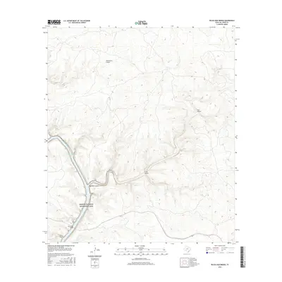
2016 Map of Pecos High Bridge
USGS Topo · Published 2016About this map
Amistad National Recreation Area dominates this West Texas landscape, where the confluence of major drainages has created a complex network of steep-walled canyons and submerged valleys. The iconic Pecos High Bridge serves as a vital crossing point over the deep gorge, standing as a primary landmark in a region defined by its extreme topography. Much of the low-lying terrain is now occupied by the Amistad Reservoir, which has altered the original hydrology of the area, though features like Dead Man Springs remain as historic water sources. The surrounding land is deeply incised by numerous named drainages, including Shackelford Canyon, Faro Canyon, and the appropriately named Crazy Canyon, illustrating the erosive power of the drainage system leading toward the Rio Grande.
Find a feature on this map
8 named features on this map. Tap any name to fly to it.
Don’t see what you’re looking for? This feature index may not catch every label — zoom into the map to look around manually.
Map Details
Editions of this 2016 Pecos High Bridge Map
This is the sole edition of this map. No revisions or reprints were ever made.
Other maps of this area

1941 · Feely
USGS Topo · 1:62,500

1943 · Shumla
USGS Topo · 1:62,500

1944 · Mouth Of Pecos
USGS Topo · 1:62,500

1944 · Baker Crossing
USGS Topo · 1:62,500

1958 · Del Rio
USGS Topo · 1:250,000

1964 · Del Rio
USGS Topo · 1:250,000
1972 · Zuberbueler Bend NW
USGS Topo · 1:24,000

1972 · Seminole Canyon
USGS Topo · 1:24,000
1972 · Comstock
USGS Topo · 1:24,000
1973 · Still Canyon
USGS Topo · 1:24,000