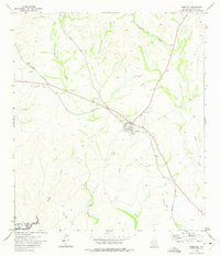
1972 Map of Comstock
USGS Topo · Published 1975About this map
Comstock serves as the central hub of this West Texas landscape, positioned at a critical junction of transportation history. The map illustrates the path of the Southern Pacific railroad alongside an older alignment labeled as the Old Railroad Grade, showing how the infrastructure adapted to the limestone terrain of Val Verde County. To the southwest, the rising waters of the Amistad Reservoir begin to fill the deep cuts of the Pecos River basin, reflecting the transformation of the region into the National Recreation Area.
Find a feature on this map
15 named features on this map. Tap any name to fly to it.
Don’t see what you’re looking for? This feature index may not catch every label — zoom into the map to look around manually.
Map Details
Editions of this 1972 Comstock Map
This is the sole edition of this map. No revisions or reprints were ever made.
Other maps of this area

1941 · Feely
USGS Topo · 1:62,500

1943 · Shumla
USGS Topo · 1:62,500

1944 · Mouth Of Pecos
USGS Topo · 1:62,500

1944 · Baker Crossing
USGS Topo · 1:62,500

1958 · Del Rio
USGS Topo · 1:250,000

1964 · Del Rio
USGS Topo · 1:250,000

1972 · California Creek
USGS Topo · 1:24,000

1972 · Seminole Canyon
USGS Topo · 1:24,000

1972 · Zuberbueler Bend
USGS Topo · 1:24,000
1972 · Box Canyon
USGS Topo · 1:24,000