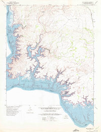
1972 Map of Box Canyon
USGS Topo · Published 1975About this map
The Amistad National Recreation Area dominates this landscape along the border of Texas and Coahuila, Mexico. Following the creation of the reservoir, residential developments like Box Canyon Estates and Amistad Acres appeared along the high ground overlooking the convoluted shoreline. The map documents the dramatic intersection of the Rio Grande and its tributaries, including Cow Creek and Chapote Draw, as they were transformed into deep canyons of the Amistad Reservoir. Further inland, the Southern Pacific tracks skirt the eastern edge of the quadrangle near the point known as Feely, while the isolated Miguel Waterhole persists in the brush country of the interior. This survey captures a moment when new recreation-focused settlements began to populate the rugged limestone plateaus above the international waters.
Find a feature on this map
15 named features on this map. Tap any name to fly to it.
Don’t see what you’re looking for? This feature index may not catch every label — zoom into the map to look around manually.
Map Details
Editions of this 1972 Box Canyon Map
This is the sole edition of this map. No revisions or reprints were ever made.
Other maps of this area

1941 · Feely
USGS Topo · 1:62,500

1943 · Devils River
USGS Topo · 1:62,500

1944 · Devils River
USGS Topo · 1:62,500

1944 · Mouth Of Pecos
USGS Topo · 1:62,500

1958 · Del Rio
USGS Topo · 1:250,000

1964 · Del Rio
USGS Topo · 1:250,000

1972 · Amistad Dam
USGS Topo · 1:24,000

1972 · California Creek
USGS Topo · 1:24,000

1972 · Seminole Canyon
USGS Topo · 1:24,000
1972 · Zuberbueler Bend
USGS Topo · 1:24,000