
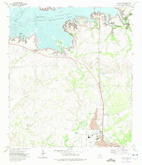
1972 Map of Amistad Dam
USGS Topo · Published 1975About this map
The Amistad Reservoir dominates this borderland landscape, where the confluence of the Rio Grande and the Devils River was transformed by the massive Amistad Dam. This 1970s survey captures the region just after the reservoir's completion, illustrating the intricate shoreline of the Amistad National Recreation Area as it winds along the United States-Mexico border. The map documents the infrastructure supporting this international project, including the U.S. Customs station and the nearby Amistad Village.
Find a feature on this map
22 named features on this map. Tap any name to fly to it.
Don’t see what you’re looking for? This feature index may not catch every label — zoom into the map to look around manually.
Map Details
Editions of this 1972 Amistad Dam Map
This is the sole edition of this map. No revisions or reprints were ever made.
Other maps of this area

1941 · Feely
USGS Topo · 1:62,500

1943 · Devils River
USGS Topo · 1:62,500

1943 · Del Rio
USGS Topo · 1:62,500

1944 · Devils River
USGS Topo · 1:62,500

1944 · Devils Lake
USGS Topo · 1:62,500

1958 · Del Rio
USGS Topo · 1:250,000

1964 · Del Rio
USGS Topo · 1:250,000

1972 · California Creek
USGS Topo · 1:24,000

1972 · Del Rio SW
USGS Topo · 1:24,000
1972 · Del Rio NW
USGS Topo · 1:24,000