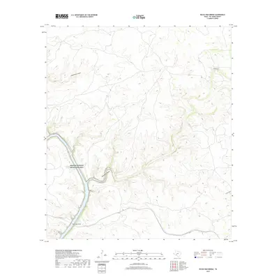
2019 Map of Pecos High Bridge
USGS Topo · Published 2019About this map
Pecos High Bridge serves as a focal point for this arid landscape in Val Verde County, spanning the steep terrain where the Pecos River corridor cuts through the limestone plateaus. The surrounding environment is defined by a series of deep, winding drainages including Shackelford Canyon, Dead Mans Canyon, and Faro Canyon, which create a complex network of relief leading toward the water. A significant portion of the southwestern quadrant is managed as the Amistad National Recreation Area, reflecting the region's importance for conservation and water management. Localized water sources like Dead Mans Springs are highlighted against the dry backdrop of the West Texas brush country. This survey illustrates the modern transportation and recreation infrastructure that traverses a landscape historically defined by these natural barriers.
Find a feature on this map
7 named features on this map. Tap any name to fly to it.
Don’t see what you’re looking for? This feature index may not catch every label — zoom into the map to look around manually.
Map Details
Editions of this 2019 Pecos High Bridge Map
This is the sole edition of this map. No revisions or reprints were ever made.
Other maps of this area

1941 · Feely
USGS Topo · 1:62,500

1943 · Shumla
USGS Topo · 1:62,500

1944 · Mouth Of Pecos
USGS Topo · 1:62,500

1944 · Baker Crossing
USGS Topo · 1:62,500

1958 · Del Rio
USGS Topo · 1:250,000

1964 · Del Rio
USGS Topo · 1:250,000
1972 · Zuberbueler Bend NW
USGS Topo · 1:24,000

1972 · Seminole Canyon
USGS Topo · 1:24,000
1972 · Comstock
USGS Topo · 1:24,000
1973 · Still Canyon
USGS Topo · 1:24,000