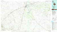
1986 Map of Pecos
USGS Topo · Published 1993About this map
Pecos serves as the central hub of this West Texas landscape, where the Missouri Pacific railroad corridor and the Pecos River intersect. The map documents a transition from the agricultural efforts around Barstow and Valley Farm to the industrial development of the Delaware Oil Field and Toyah Gas Field. The presence of an Aqueduct and multiple levees near Toyah Lake underscores the intensive water management required in this arid region, where ephemeral drainages like Salt Draw and Toyah Creek dominate the terrain. Genealogists can locate Mount Evergreen Cem on the outskirts of town, while local historians may find interest in the specialized Automotive Proving Ground to the east. From the southern reaches near Saragosa to the limestone heights of Round Mountain, the sheet captures a region defined by its energy production and the legacy of the rail-and-river economy.
Find a feature on this map
60 named features on this map. Tap any name to fly to it.
Don’t see what you’re looking for? This feature index may not catch every label — zoom into the map to look around manually.
Map Details
Editions of this 1986 Pecos Map
2 editions found
Other maps of this area

1894 · Valentine
USGS Topo · 1:125,000

1894 · Fort Davis
USGS Topo · 1:125,000

1897 · Valentine
USGS Topo · 1:125,000

1897 · Fort Davis
USGS Topo · 1:125,000

1921 · Toyah
USGS Topo · 1:125,000

1921 · Fort Stockton
USGS Topo · 1:62,500

1923 · Fort Stockton
USGS Topo · 1:62,500

1928 · Kent
USGS Topo · 1:125,000

1928 · Comanche Spring
USGS Topo · 1:125,000

1929 · Hovey
USGS Topo · 1:125,000