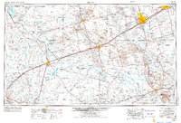
1954 Map of Pecos
USGS Topo · Published 1980About this map
Odessa and Midland anchor the eastern reaches of this West Texas landscape, where the Permian Basin's mid-century petroleum and ranching identity is clearly etched. The map captures a vast network of infrastructure following the Pecos River valley, including the Texas and Pacific railroad line that spurred the growth of settlements like Pecos, Monahans, and Pyote. The terrain is defined by the sweeping Sand Hills, preserved in part by Monahans Sand Hills State Park, and several prominent local landmarks such as King Mountain and Square Top Mountain. Water management in this arid region is visible through features like Red Bluff Lake and the Imperial Reservoir, which serve as vital points along the Pecos River. The survey also documents smaller ranching and oil communities such as Mentone, Kermit, and Goldsmith at a time of significant energy expansion.
Find a feature on this map
70 named features on this map. Tap any name to fly to it.
Don’t see what you’re looking for? This feature index may not catch every label — zoom into the map to look around manually.
Map Details
Editions of this 1954 Pecos Map
3 editions found