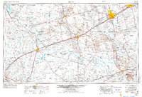
1954 Map of Pecos
USGS Topo · Published 1974About this map
The Pecos River carves through this arid landscape, serving as a vital artery for early irrigation projects and livestock in the mid-1950s. This survey, updated in the 1970s, reveals a region defined by its extreme terrain and expanding energy sector. Extensive Sand Hills dominate the northeast, punctuated by the Monahans Sand Hills State Park. The infrastructure of the West Texas oil boom is evident in the dense network of pipelines and service roads surrounding Kermit, Wink, and Monahans. Transportation corridors follow the path of the Texas and Pacific and the Pecos Valley Southern railroads, which helped facilitate the shipment of cattle and petroleum. Smaller communities like Mentone and Verhalen appear alongside the expansive waters of the Red Bluff Reservoir and Imperial Reservoir, illustrating the human effort to manage water in a desert environment.
Find a feature on this map
80 named features on this map. Tap any name to fly to it.
Don’t see what you’re looking for? This feature index may not catch every label — zoom into the map to look around manually.
Map Details
Editions of this 1954 Pecos Map
3 editions found

Other maps of this area

1894 · Valentine
USGS Topo · 1:125,000

1894 · Fort Davis
USGS Topo · 1:125,000

1897 · Valentine
USGS Topo · 1:125,000

1897 · Fort Davis
USGS Topo · 1:125,000

1921 · Toyah
USGS Topo · 1:125,000

1921 · Fort Stockton
USGS Topo · 1:62,500

1923 · Fort Stockton
USGS Topo · 1:62,500

1925 · Orla 2-b
USGS Topo · 1:48,000

1928 · Crane
USGS Topo · 1:125,000

1928 · Kent
USGS Topo · 1:125,000