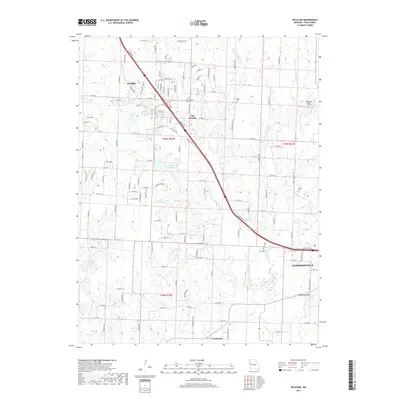
2017 Map of Peculiar
USGS Topo · Published 2017About this map
The eastern edges of Peculiar and the northwestern approach to Harrisonville define this portion of Cass County. This suburbanizing landscape is marked by the split between the older settlement at Old Peculiar and the more modern residential expansions near Peculiar City Reservoir and Harper Lake. The terrain is drained by the extensive network of the East Branch South Grand River and its tributaries, including Wolf Creek and Polecat Creek. For genealogists, the map preserves several local burial grounds, such as Peculiar Cemetery, Wills Cemetery, and Brown Cemetery, situated among a road network that transitions from traditional grid lines like School Road to winding suburban drives. At the southern edge, the small community of Prettyman sits along the section line, illustrating the persistent rural settlement pattern that exists alongside the growing corridor of the regional highway system.
Find a feature on this map
126 named features on this map. Tap any name to fly to it.
Don’t see what you’re looking for? This feature index may not catch every label — zoom into the map to look around manually.
Map Details
Editions of this 2017 Peculiar Map
This is the sole edition of this map. No revisions or reprints were ever made.
Other maps of this area

1887 · Harrisonville
USGS Topo · 1:125,000

1887 · Olathe
USGS Topo · 1:125,000

1892 · Harrisonville
USGS Topo · 1:125,000

1893 · Olathe
USGS Topo · 1:125,000

1894 · Harrisonville
USGS Topo · 1:125,000

1947 · Lawrence
USGS Topo · 1:250,000

1950 · Lawrence
USGS Topo · 1:250,000
1953 · Belton
USGS Topo · 1:24,000

1953 · Freeman
USGS Topo · 1:24,000

1953 · West Line
USGS Topo · 1:24,000