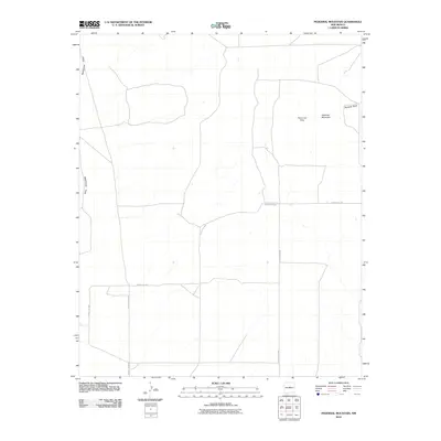
2010 Map of Pedernal Mountain
USGS Topo · Published 2010About this map
Pedernal Mountain and the broader Pedernal Hills rise as the defining landmarks of this high-altitude landscape in Torrance County. The terrain is shaped by extensive drainage systems, most notably McGillivray Draw in the west and Pintada Draw to the east. This 2010 survey illustrates a sparse settlement pattern characteristic of the region, anchored by the Waller Ranch. The human imprint on this arid environment is largely defined by a simple network of thoroughfares, including County Rd-C091, County Rd-C089, and County Rd-C088, which navigate the elevation changes and seasonal watercourses of the desert upland.
Find a feature on this map
8 named features on this map. Tap any name to fly to it.
Don’t see what you’re looking for? This feature index may not catch every label — zoom into the map to look around manually.
Map Details
Editions of this 2010 Pedernal Mountain Map
This is the sole edition of this map. No revisions or reprints were ever made.
Other maps of this area

1954 · Fort Sumner
USGS Topo · 1:250,000

1958 · Fort Sumner
USGS Topo · 1:250,000

1960 · Lobo Hill
USGS Topo · 1:62,500
1978 · Waller Ranch
USGS Topo · 1:24,000

1978 · Pedernal Mountain
USGS Topo · 1:24,000

1978 · Pedernal
USGS Topo · 1:24,000

1978 · North Lucy
USGS Topo · 1:24,000
1978 · Rock Lake
USGS Topo · 1:24,000

1978 · Negra
USGS Topo · 1:24,000

1978 · Lucy
USGS Topo · 1:24,000