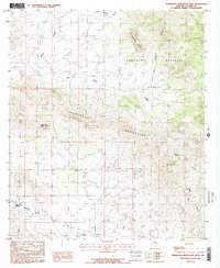
1986 Map of Pedregosa Mountains West
USGS Topo · Published 1986About this map
Pedregosa Mountains dominate this 1980s landscape, characterized by dramatic desert landforms and deep drainage systems. The map captures a section of the Coronado National Forest, where prominent peaks like Packsaddle Mountain and the distinctive Castle Dome rise above the surrounding terrain. To the south, Poverty Flat suggests the modest nature of human encampment in this arid environment, while evidence of extraction persists at the southern Quarries and a scattered Prospect.
Find a feature on this map
17 named features on this map. Tap any name to fly to it.
Don’t see what you’re looking for? This feature index may not catch every label — zoom into the map to look around manually.
Map Details
Editions of this 1986 Pedregosa Mountains West Map
2 editions found
Other maps of this area

1914 · Douglas
USGS Topo · 1:62,500

1916 · Pearce
USGS Topo · 1:125,000

1916 · Douglas
USGS Topo · 1:125,000

1917 · Chiricahua
USGS Topo · 1:125,000

1919 · Douglas
USGS Topo · 1:125,000

1919 · Perilla
USGS Topo · 1:125,000

1919 · Chiricahua
USGS Topo · 1:125,000

1922 · Swisshelm
USGS Topo · 1:62,500

1925 · Douglas
USGS Topo · 1:62,500

1926 · Pedregosa
USGS Topo · 1:62,500