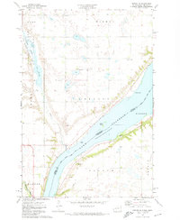
1971 Map of Peever NE
USGS Topo · Published 1974About this map
Lake Traverse dominates the eastern boundary of this 1970s landscape, marking the border between Roberts and Traverse counties. The map captures a quiet agricultural and natural region characterized by its glacial water features, including the prominent Lake Bdesaka and the sprawling Cottonwood Slough protected within a State Wildlife Management Area. Cultural landmarks are scattered throughout the rural townships of Hart, Bryant, and Folsom, where researchers can find Trinity Church, a local Townhall, and several small burial sites labeled simply as Cem and Graves. The terrain is shaped by the descent toward the Minnesota River in the south, with several Gravel Pits and public access points indicating a landscape managed for both utility and recreation. The boundary of the Sisseton Indian Reservation is also clearly delineated, crossing the waters of Lake Traverse near Jensen Island.
Find a feature on this map
27 named features on this map. Tap any name to fly to it.
Don’t see what you’re looking for? This feature index may not catch every label — zoom into the map to look around manually.
Map Details
Editions of this 1971 Peever NE Map
This is the sole edition of this map. No revisions or reprints were ever made.
Other maps of this area

1915 · White Rock
USGS Topo · 1:62,500

1916 · Peever
USGS Topo · 1:62,500

1916 · Beardsley
USGS Topo · 1:62,500

1917 · New Effington
USGS Topo · 1:62,500

1918 · Peever
USGS Topo · 1:62,500

1918 · White Rock
USGS Topo · 1:62,500

1918 · Beardsley
USGS Topo · 1:62,500

1953 · Milbank
USGS Topo · 1:250,000

1958 · Milbank
USGS Topo · 1:250,000

1971 · Browns Valley
USGS Topo · 1:24,000