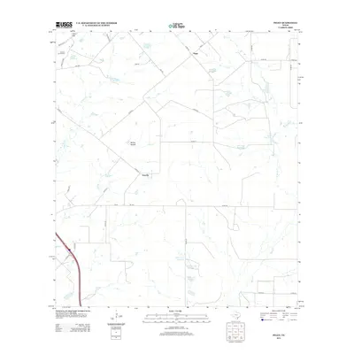
2012 Map of Peggy
USGS Topo · Published 2012About this map
The Lipan Hills and McCoy Hollow define the undulating landscape of south-central Texas in this 2012 survey. The area is characterized by a sparse, ranch-oriented settlement pattern centered around Peggy and Esseville. Water management is a primary feature of the local geography, visible through a series of numbered reservoirs and family-named water bodies like Lillian Esse Lake, James Esse Lake, and the Taylor Lake Number 1 complex. A network of rural roads, including FM-1099 and Oil Field Rd, connects these remote properties across a terrain drained by Olmos Cr, Salt Br, and Bell Cr. The presence of the Hacienda de la Tordilla in the northwest suggests a deep-rooted agricultural or ranching history in Atascosa County, where the economy remains tied to the land and its intermittent creek systems.
Find a feature on this map
46 named features on this map. Tap any name to fly to it.
Don’t see what you’re looking for? This feature index may not catch every label — zoom into the map to look around manually.
Map Details
Editions of this 2012 Peggy Map
This is the sole edition of this map. No revisions or reprints were ever made.
Other maps of this area

1930 · Whitsett
USGS Topo · 1:62,500

1931 · Falls City
USGS Topo · 1:62,500

1942 · Whitsett
USGS Topo · 1:62,500

1953 · Crystal City
USGS Topo · 1:250,000

1955 · Crystal City
USGS Topo · 1:250,000

1956 · Suniland
USGS Topo · 1:62,500

1956 · Pleasanton
USGS Topo · 1:62,500

1961 · Crystal City
USGS Topo · 1:250,000
1961 · Coy City
USGS Topo · 1:24,000
1961 · Fashing
USGS Topo · 1:24,000