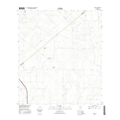
2016 Map of Peggy
USGS Topo · Published 2016About this map
The border between Atascosa and Live Oak Counties bisects this South Texas landscape, defined by a series of named ranching water bodies and creek drainage systems. The small community of Peggy sits at the junction of FM 99 and Co RD 410, serving as a central point in an area characterized by intermittent water sources like Olmos Cr and Salt Br. Further south, the settlement of Esseville occupies a position near Merriman Hollow, surrounded by numerous engineered reservoirs such as Taylor Lake Number 1 and Esse Lake Number 8. The map reveals a land utilized for livestock and resource management, with family names preserved in features like Lillian Esse Lake and James Esse Lake. Terrain variations are noted at Lipan Hills and McCoy Hollow, while a network of farm-to-market roads and county routes connects these isolated ranching outposts.
Find a feature on this map
42 named features on this map. Tap any name to fly to it.
Don’t see what you’re looking for? This feature index may not catch every label — zoom into the map to look around manually.
Map Details
Editions of this 2016 Peggy Map
This is the sole edition of this map. No revisions or reprints were ever made.
Other maps of this area

1930 · Whitsett
USGS Topo · 1:62,500

1931 · Falls City
USGS Topo · 1:62,500

1942 · Whitsett
USGS Topo · 1:62,500

1953 · Crystal City
USGS Topo · 1:250,000

1955 · Crystal City
USGS Topo · 1:250,000

1956 · Suniland
USGS Topo · 1:62,500

1956 · Pleasanton
USGS Topo · 1:62,500

1961 · Crystal City
USGS Topo · 1:250,000
1961 · Coy City
USGS Topo · 1:24,000
1961 · Fashing
USGS Topo · 1:24,000