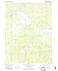
1980 Map of Pegleg Mountain
USGS Topo · Published 1980About this map
McCoy Flat Reservoir and Hog Flat Reservoir dominate this high-elevation landscape within the Lassen National Forest. The map captures a transition in mountain infrastructure, where the Western Pacific railroad tracks and the Old Railroad Grade illustrate the historic movement of timber and passengers through the northern Sierras. Near Westwood Junction, the confluence of rail lines and water management features like the Gaging Station on the Susan River point to the region's managed wilderness character. Terrain features like Pegleg Mtn, topped with a Lookout Tower, and Chaparral Hill rise above the flats and basins. Evidence of local industry is scattered across the quadrant in the form of a Cinder Pit, Borrow Pit, and various Quarries, marking the physical extraction required to maintain the roads and rail beds in this demanding environment.
Find a feature on this map
17 named features on this map. Tap any name to fly to it.
Don’t see what you’re looking for? This feature index may not catch every label — zoom into the map to look around manually.
Map Details
Editions of this 1980 Pegleg Mountain Map
This is the sole edition of this map. No revisions or reprints were ever made.
Other maps of this area

1886 · Honey Lake
USGS Topo · 1:250,000

1886 · Lassen Peak
USGS Topo · 1:250,000

1891 · Honey Lake
USGS Topo · 1:250,000

1892 · Lassen Peak
USGS Topo · 1:250,000

1893 · Honey Lake
USGS Topo · 1:250,000

1894 · Lassen Peak
USGS Topo · 1:250,000

1939 · Halls Flat
USGS Topo · 1:125,000

1955 · Westwood
USGS Topo · 1:62,500

1955 · Westwood
USGS Topo · 1:250,000

1956 · Chester
USGS Topo · 1:62,500