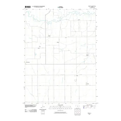
2010 Map of Pekin
USGS Topo · Published 2010About this map
Martinsburg and the small settlement of Pekin anchor this southeastern Iowa landscape, where agricultural tradition meets a complex network of waterways. The South Skunk River meanders across the northern reaches, while numerous tributaries like Steady Run, Twin Grove Creek, and Little Competine Creek drain the surrounding farmland. This area is notably dense with small family and community burial grounds, such as the Van Orsdall Cemetery and the Skinner-McConnell Cemetery, which provide significant touchstones for genealogists. The map also documents smaller rural hamlets like Linby, Walden, and Nugent, connected by a grid of county roads and the arterial Wapello Keokuk Rd. The presence of the Rock Creek Church and Cemetery further illustrates the established social and religious centers that have long served this rural Keokuk County community.
Find a feature on this map
33 named features on this map. Tap any name to fly to it.
Don’t see what you’re looking for? This feature index may not catch every label — zoom into the map to look around manually.
Map Details
Editions of this 2010 Pekin Map
This is the sole edition of this map. No revisions or reprints were ever made.
Other maps of this area

1954 · Des Moines
USGS Topo · 1:250,000

1956 · Des Moines
USGS Topo · 1:250,000

1956 · Farson
USGS Topo · 1:24,000

1956 · Ottumwa North
USGS Topo · 1:62,500

1957 · Des Moines
USGS Topo · 1:250,000

1965 · Harper
USGS Topo · 1:24,000

1965 · Sigourney
USGS Topo · 1:24,000

1965 · Delta
USGS Topo · 1:24,000

1969 · Des Moines
USGS Topo · 1:250,000
1980 · Ollie
USGS Topo · 1:24,000