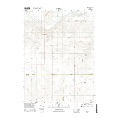
2015 Map of Pekin
USGS Topo · Published 2015About this map
Martinsburg and the nearby rail-stop communities of Pekin and Linby anchor this agricultural landscape at the meeting point of Keokuk, Wapello, and Jefferson Counties. The survey reveals a terrain defined by the northern passage of the South Skunk River and a network of drainages including Steady Run, Twin Grove Cr, and Rock Cr. For genealogists and local historians, several small family and community burial grounds are preserved across the sections, such as the Van Orsdall Cem and Skinner-McConnell Cem. The map's layout reflects a deeply established section-line road system that connects these small towns to rural landmarks like the Rock Creek Church and Cem and the Mount Zion Cem. The convergence of county lines at Wapello Keokuk Rd highlights the importance of these townships in the regional transportation and social network of southeastern Iowa.
Find a feature on this map
34 named features on this map. Tap any name to fly to it.
Don’t see what you’re looking for? This feature index may not catch every label — zoom into the map to look around manually.
Map Details
Editions of this 2015 Pekin Map
This is the sole edition of this map. No revisions or reprints were ever made.
Other maps of this area

1954 · Des Moines
USGS Topo · 1:250,000

1956 · Des Moines
USGS Topo · 1:250,000

1956 · Farson
USGS Topo · 1:24,000

1956 · Ottumwa North
USGS Topo · 1:62,500

1957 · Des Moines
USGS Topo · 1:250,000

1965 · Harper
USGS Topo · 1:24,000

1965 · Sigourney
USGS Topo · 1:24,000

1965 · Delta
USGS Topo · 1:24,000

1969 · Des Moines
USGS Topo · 1:250,000
1980 · Ollie
USGS Topo · 1:24,000