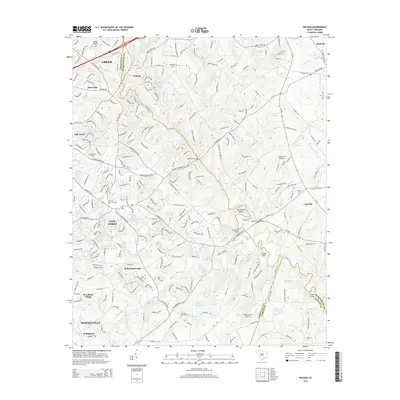
2014 Map of Pelham
USGS Topo · Published 2014About this map
The Enoree River winds through this landscape on the border of Greenville and Spartanburg counties, defining a region where early settlements and modern growth meet. Near Pelham Falls, the river's path is marked by historical crossings like Bennetts Bridge and distinctive natural features such as Horseshoe Bend. The map documents a transition from rural homesteads to residential development, anchored by established communities like Greer, Simpsonville, and Reidville. Small crossroads and historic markers are prevalent throughout, including Bells Crossroads and several family or community burial grounds such as Antioch Cem and Mayfield Cem. The survey also highlights the local aviation infrastructure of the period, featuring both the Chandelle Airport and Parker Field Airport. Water resources are well-represented by various ponds and tributaries, including G Brockman Pond and Gilder Cr, which weave through the terrain near Indian Hill.
Find a feature on this map
243 named features on this map. Tap any name to fly to it.
Don’t see what you’re looking for? This feature index may not catch every label — zoom into the map to look around manually.
Map Details
Editions of this 2014 Pelham Map
This is the sole edition of this map. No revisions or reprints were ever made.
Other maps of this area

1935 · Greer
USGS Topo · 1:48,000

1935 · Greenville
USGS Topo · 1:48,000

1938 · Greenville
USGS Topo · 1:62,500

1938 · Greer
USGS Topo · 1:62,500

1954 · Greenville
USGS Topo · 1:250,000

1957 · Fountain Inn
USGS Topo · 1:62,500

1957 · Williamston
USGS Topo · 1:62,500

1957 · Greer
USGS Topo · 1:62,500

1957 · Greenville
USGS Topo · 1:62,500

1958 · Greenville
USGS Topo · 1:250,000