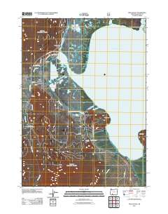
2011 Map of Pelican Bay
USGS Topo · Published 2011About this map
Upper Klamath Lake dominates the eastern half of this landscape, where the marshy transition to the mainland is navigated by Pelican Cut Canal and several winding waterways including Crystal Creek and Recreation Creek. Along the northwestern shore, the settlement of Rocky Point and nearby Harriman Lodge reflect the area's long-standing connection to lakeside recreation and lodging. The terrain rises sharply away from the water towards Pelican Butte Road, revealing a landscape marked by both natural features like Odessa Spring and human industry, evidenced by the Pelican Cinder Pit and Long Rifle Cinder Pit. Farther south, the Mountain Lakes Organizational Camp sits tucked away near the headwaters of Varney Creek, while the shoreline extends into Ball Bay at Coon Point.
Find a feature on this map
31 named features on this map. Tap any name to fly to it.
Don’t see what you’re looking for? This feature index may not catch every label — zoom into the map to look around manually.
Map Details
Editions of this 2011 Pelican Bay Map
This is the sole edition of this map. No revisions or reprints were ever made.
Other maps of this area

1889 · Klamath
USGS Topo · 1:250,000

1891 · Ashland
USGS Topo · 1:250,000

1893 · Ashland
USGS Topo · 1:250,000

1894 · Klamath
USGS Topo · 1:250,000

1897 · Ashland
USGS Topo · 1:250,000

1955 · Lake O' Woods
USGS Topo · 1:62,500

1955 · Pelican Butte
USGS Topo · 1:62,500

1955 · Klamath Falls
USGS Topo · 1:250,000

1955 · Medford
USGS Topo · 1:250,000

1957 · Medford
USGS Topo · 1:250,000