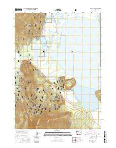
2017 Map of Pelican Bay
USGS Topo · Published 2017About this map
Upper Klamath National Wildlife Refuge and the southern slopes of the Winema National Forest dominate this lakeside landscape. The map highlights the specialized water trails of the Upper Klamath Canoe route, winding through the marshes of Pelican Bay and Agency Lake. This intricate network of wetlands is fed by numerous natural sources, including Harriman Spring, Odessa Spring, and Wampler Spring, which emerge at the base of the rising timberland. Small lakeside settlements such as Rocky Point and Point Comfort serve as access hubs for the recreational and conservation lands. To the southwest, the terrain climbs sharply toward the summit of Mt Harriman, illustrating the transition from the marshy lowlands of Upper Klamath Lake to the high-elevation forest. This survey provides a clear view of the complex hydrology and forest access roads defining the western shore in the early 21st century.
Find a feature on this map
46 named features on this map. Tap any name to fly to it.
Don’t see what you’re looking for? This feature index may not catch every label — zoom into the map to look around manually.
Map Details
Editions of this 2017 Pelican Bay Map
This is the sole edition of this map. No revisions or reprints were ever made.
Other maps of this area

1889 · Klamath
USGS Topo · 1:250,000

1891 · Ashland
USGS Topo · 1:250,000

1893 · Ashland
USGS Topo · 1:250,000

1894 · Klamath
USGS Topo · 1:250,000

1897 · Ashland
USGS Topo · 1:250,000

1955 · Lake O' Woods
USGS Topo · 1:62,500

1955 · Pelican Butte
USGS Topo · 1:62,500

1955 · Klamath Falls
USGS Topo · 1:250,000

1955 · Medford
USGS Topo · 1:250,000

1957 · Medford
USGS Topo · 1:250,000