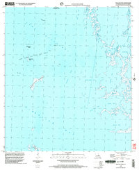
1998 Map of Pelican Pass
USGS Topo · Published 2003About this map
Industrial infrastructure meets a shifting deltaic landscape in this coastal survey of the Lake Raccourci Oil and Gas Field. Numerous offshore platforms dot the waters of Lake Raccourci and Lake Barre Oil and Gas Field, illustrating the heavy extraction activity in the Gulf marshes at the close of the 20th century. The topography is defined by fragmented landmasses like the Philo Brice Islands and Northwest Island, surrounded by a complex network of tidal openings including Pelican Pass and the curiously named Wrong Name Pass. The eastern edge reveals the intricate hydrology of Bayou Rosa and China Bayou as they feed into Little Lake. This map serves as a detailed record of the intersection between Louisiana's energy industry and its fragile marshland environments, including areas like Jacko Camp Bay and Pierle Bay.
Find a feature on this map
26 named features on this map. Tap any name to fly to it.
Don’t see what you’re looking for? This feature index may not catch every label — zoom into the map to look around manually.
Map Details
Editions of this 1998 Pelican Pass Map
This is the sole edition of this map. No revisions or reprints were ever made.
Other maps of this area

1892 · Cheniere Caminada
USGS Topo · 1:62,500

1892 · Creole
USGS Topo · 1:62,500

1894 · Timbalier
USGS Topo · 1:62,500

1894 · Lake Felicity
USGS Topo · 1:62,500

1935 · Timbalier Island
USGS Topo · 1:31,680

1935 · Bay Courant
USGS Topo · 1:31,680

1935 · Pelican Pass
USGS Topo · 1:31,680

1935 · Mink Bayou
USGS Topo · 1:31,680

1935 · Calumet Island
USGS Topo · 1:31,680

1935 · Leeville
USGS Topo · 1:31,680