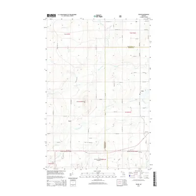
2014 Map of Pelkie
USGS Topo · Published 2014About this map
Pelkie and the surrounding rural landscape in Baraga County are defined by a complex web of river systems and forest lands. The terrain is marked by Limestone Mtn rising above the winding paths of the Sturgeon River and its branches. This 2014 survey illustrates the local infrastructure, showing how small settlements like Elo and Hazel are connected by a network of named roads such as Tapiola Rd and Haataja Rd. To the south, the boundary of the Ottawa National Forest marks a transition from private holdings to managed wilderness. Genealogists and local historians can locate specific landmarks including Pelkie Cem and Alston Cem, while the detailed labeling of various creeks like Silver River and Pine Cr reveals the drainage patterns that have historically shaped agriculture and settlement in this Upper Peninsula region.
Find a feature on this map
63 named features on this map. Tap any name to fly to it.
Don’t see what you’re looking for? This feature index may not catch every label — zoom into the map to look around manually.
Map Details
Editions of this 2014 Pelkie Map
This is the sole edition of this map. No revisions or reprints were ever made.
Other maps of this area

1954 · Rousseau
USGS Topo · 1:62,500

1954 · Pelkie
USGS Topo · 1:62,500

1954 · Winona
USGS Topo · 1:62,500

1954 · Sidnaw
USGS Topo · 1:62,500

1958 · Iron River
USGS Topo · 1:250,000

1960 · Iron River
USGS Topo · 1:250,000

1961 · Iron River
USGS Topo · 1:250,000

1967 · Iron River
USGS Topo · 1:250,000
1982 · Nisula
USGS Topo · 1:25,000
1982 · Donken
USGS Topo · 1:25,000