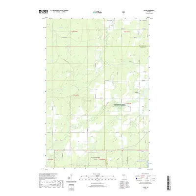
2019 Map of Pelkie
USGS Topo · Published 2019About this map
The unincorporated community of Pelkie serves as a focal point for this section of the Upper Peninsula, situated near the winding course of the Sturgeon River. The landscape is defined by the prominent Limestone Mtn and a complex network of waterways, including the North Branch Otter River and the Silver River. For those researching family history in Baraga County, the map identifies local landmarks such as Pelkie Cem and Alston Cem. The region reflects a mix of conservation and rural development, with significant portions of the Ottawa National Forest and the Sturgeon Wild and Scenic River protected corridors. Numerous family-named roads, including Kauppinen Rd and Froberg Rd, crisscross the township, tracing the settlement patterns of the area's residents.
Find a feature on this map
87 named features on this map. Tap any name to fly to it.
Don’t see what you’re looking for? This feature index may not catch every label — zoom into the map to look around manually.
Map Details
Editions of this 2019 Pelkie Map
This is the sole edition of this map. No revisions or reprints were ever made.
Other maps of this area

1954 · Rousseau
USGS Topo · 1:62,500

1954 · Pelkie
USGS Topo · 1:62,500

1954 · Winona
USGS Topo · 1:62,500

1954 · Sidnaw
USGS Topo · 1:62,500

1958 · Iron River
USGS Topo · 1:250,000

1960 · Iron River
USGS Topo · 1:250,000

1961 · Iron River
USGS Topo · 1:250,000

1967 · Iron River
USGS Topo · 1:250,000
1982 · Nisula
USGS Topo · 1:25,000
1982 · Donken
USGS Topo · 1:25,000