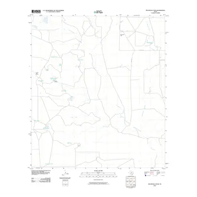
2010 Map of Peloncillo Peak
USGS Topo · Published 2010About this map
Peloncillo Peak rises above a landscape defined by an extensive network of water management features in this Maverick County study. The terrain is crisscrossed by numerous ephemeral watercourses, including Lindsey Creek, Elm Creek, and Stricklin Creek, which feed into an array of specialized ranching tanks. Named features such as Snake Tank, Birdnest Tank, and the aptly named Hard Luck Tank highlight the critical importance of water storage in this semi-arid environment. Ranching infrastructure is further evidenced by the Dunbar Ranch Airport and the Dunbar Lake Dam, which contains Dunbar Lake. Movement through the area is facilitated by Farm Rd 481 and local routes like Anacacho Rd, connecting the scattered ranching operations. The distribution of these tanks and private airstrips suggests a region dedicated to large-scale land management and livestock operations during the early 21st century.
Find a feature on this map
22 named features on this map. Tap any name to fly to it.
Don’t see what you’re looking for? This feature index may not catch every label — zoom into the map to look around manually.
Map Details
Editions of this 2010 Peloncillo Peak Map
This is the sole edition of this map. No revisions or reprints were ever made.
Other maps of this area

1896 · Brackett
USGS Topo · 1:125,000

1897 · Brackett
USGS Topo · 1:125,000

1940 · Paloma
USGS Topo · 1:62,500

1940 · Chacon Creek
USGS Topo · 1:62,500

1944 · Spofford
USGS Topo · 1:62,500

1949 · Cline
USGS Topo · 1:62,500

1958 · Eagle Pass
USGS Topo · 1:250,000

1958 · Del Rio
USGS Topo · 1:250,000

1964 · Del Rio
USGS Topo · 1:250,000

1965 · Eagle Pass
USGS Topo · 1:250,000