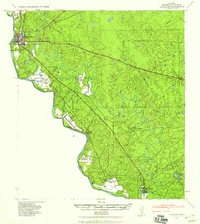
1965 Map of Eagle Pass
USGS Topo · Published 1965About this map
The Rio Grande carves the western boundary of this landscape, anchoring the international border between United States and Mexico in the mid-1960s. The settlement at Eagle Pass serves as the primary regional hub, with its surrounding territory defined by an extensive network of family-held cattle and livestock operations such as Burr Ranch, Paloma Ranch, and Farias Ranch. The rural character is further detailed through a complex drainage system including Elm Creek and Salado Creek, which supported the agrarian and ranching economy of Maverick County.
Find a feature on this map
55 named features on this map. Tap any name to fly to it.
Don’t see what you’re looking for? This feature index may not catch every label — zoom into the map to look around manually.
Map Details
Editions of this 1965 Eagle Pass Map
This is the sole edition of this map. No revisions or reprints were ever made.
Historical Maps of Eagle Pass Through Time
4 maps found