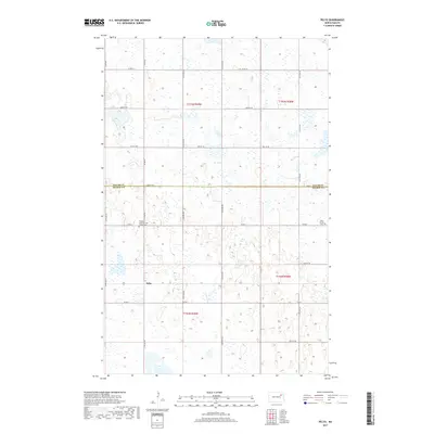
2017 Map of Pelto
USGS Topo · Published 2017About this map
Pelto sits within a landscape defined by its agricultural grid and numerous wetlands in this 2017 study of the North Dakota prairie. The map documents the boundary between Walsh Co and Nelson Co, providing a precise look at the township and range lines that structured settlement in this region. Genealogists will find particular value in the documentation of local burial sites, such as the Finnish Lutheran Cem Finnish Cem and West Forest Cem, which reflect the ethnic heritage and early community centers of the area. A network of section roads, including Co Rd 1 and Co Rd 2, connects these quiet landmarks across the undulating terrain of the Red River Valley hinterlands.
Find a feature on this map
17 named features on this map. Tap any name to fly to it.
Don’t see what you’re looking for? This feature index may not catch every label — zoom into the map to look around manually.
Map Details
Editions of this 2017 Pelto Map
This is the sole edition of this map. No revisions or reprints were ever made.
Other maps of this area

1953 · Devils Lake
USGS Topo · 1:250,000

1956 · Devils Lake
USGS Topo · 1:250,000

1970 · Lakota
USGS Topo · 1:24,000

1971 · Michigan West
USGS Topo · 1:24,000
1971 · Michigan East
USGS Topo · 1:24,000

1971 · Whitman
USGS Topo · 1:24,000

1971 · Brocket
USGS Topo · 1:24,000

1971 · Pelto
USGS Topo · 1:24,000

1972 · Adams SW
USGS Topo · 1:24,000

1972 · Lawton
USGS Topo · 1:24,000