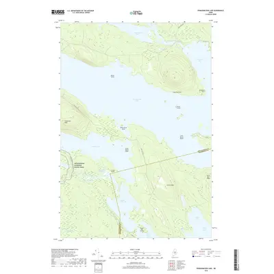
2018 Map of Pemadumcook Lake
USGS Topo · Published 2018About this map
Pemadumcook Lake dominates this central Maine landscape, serving as a massive hydraulic hub connecting the West Branch Penobscot River and a complex of smaller basins including Jo-Mary Lake and Ambejejus Lake. This 2018 survey reveals a terrain defined by its water-and-woods character, where the Appalachian National Scenic Trail winds through the southwestern corner near Potaywadjo Ridge and Cooper Brook. The map illustrates a region managed for both conservation and timber access, with named paths like the Tirio Access Rd cutting through the dense forest between Lincoln Ridge and the shores of Middle Jo-Mary Lake. Local landmarks such as White Horse Island and Sweet Potato Island dot the expanse of the larger lakes, while the Piscataquis and Penobscot county line bisects the southern waters near Turkey Tail Lake.
Find a feature on this map
39 named features on this map. Tap any name to fly to it.
Don’t see what you’re looking for? This feature index may not catch every label — zoom into the map to look around manually.
Map Details
Editions of this 2018 Pemadumcook Lake Map
This is the sole edition of this map. No revisions or reprints were ever made.
Other maps of this area

1927 · Katahdin
USGS Topo · 1:48,000

1930 · Katahdin
USGS Topo · 1:62,500

1949 · Katahdin
USGS Topo · 1:62,500

1951 · Norcross
USGS Topo · 1:62,500

1952 · Jo-Mary Mountain
USGS Topo · 1:62,500

1954 · Harrington Lake
USGS Topo · 1:62,500

1954 · Millinocket
USGS Topo · 1:250,000

1958 · Millinocket
USGS Topo · 1:250,000

1960 · Millinocket
USGS Topo · 1:250,000
1978 · Trout Mountain
USGS Topo · 1:24,000