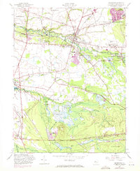
1957 Map of Pemberton
USGS Topo · Published 1971About this map
The North Branch Rancocas Creek and its southern counterpart define the landscape of this Burlington County region, where the Penn Central railroad corridors connect agricultural and industrial hubs. In the mid-20th century, the area surrounding Pemberton served as a vital community center, featuring significant public infrastructure including the County Hospital and the County Welfare Home. The map illustrates the region's agricultural roots through numerous Cranberry Bogs scattered across the lowlands of Southampton and Pemberton townships.
Find a feature on this map
57 named features on this map. Tap any name to fly to it.
Don’t see what you’re looking for? This feature index may not catch every label — zoom into the map to look around manually.
Map Details
Editions of this 1957 Pemberton Map
4 editions found
Other maps of this area

1888 · Bordentown
USGS Topo · 1:62,500

1888 · Pemberton
USGS Topo · 1:62,500

1888 · Mount Holly
USGS Topo · 1:62,500

1890 · Burlington
USGS Topo · 1:62,500

1893 · Bordentown
USGS Topo · 1:62,500

1893 · Burlington
USGS Topo · 1:62,500

1894 · Pemberton
USGS Topo · 1:62,500

1894 · Mount Holly
USGS Topo · 1:62,500

1898 · Pemberton
USGS Topo · 1:62,500

1898 · Mount Holly
USGS Topo · 1:62,500
Featured Places
- Southampton Township, NJ
- Tabernacle Township, NJ
- Eastampton Township, NJ
- Springfield Township, NJ
- Pemberton, NJ