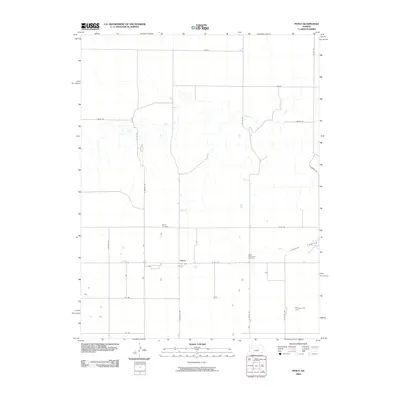
2009 Map of Pence
USGS Topo · Published 2009About this map
Pence sits as a quiet focal point in western Kansas, where the organized grid of county roads meets the wandering paths of intermittent watercourses. The landscape is defined by the drainage of Chalk Creek, which cuts through the northern half of the territory, and the more dramatic relief of Timber Canyon in the southeast. This 2009 survey highlights a rural layout where agricultural life and local heritage intersect at sites like Pence Cemetery and the Scott Mennonite Cemetery. The intersection of W Rd 270 and N Beaver Rd anchors the local transportation network, while the label Coyote in the northeast suggests a specific local landmark or property within this High Plains setting. The transition from flat sections like Dakota to the broken ground of the canyons illustrates the varied topography found in this corner of Scott County.
Find a feature on this map
21 named features on this map. Tap any name to fly to it.
Don’t see what you’re looking for? This feature index may not catch every label — zoom into the map to look around manually.
Map Details
Editions of this 2009 Pence Map
This is the sole edition of this map. No revisions or reprints were ever made.
Other maps of this area

1939 · Lake Mc Bride
USGS Topo · 1:24,000

1939 · Sandon
USGS Topo · 1:62,500

1939 · Pence
USGS Topo · 1:62,500

1941 · Pence
USGS Topo · 1:62,500

1942 · Sandon
USGS Topo · 1:62,500

1942 · Lake Mc Bride
USGS Topo · 1:31,680

1955 · Scott City
USGS Topo · 1:250,000

1958 · Scott City
USGS Topo · 1:250,000

1974 · Elkader SW
USGS Topo · 1:24,000
1974 · Lone Butte
USGS Topo · 1:24,000