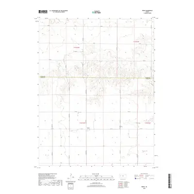
2018 Map of Pence
USGS Topo · Published 2018About this map
Pence sits at a crossroads of the High Plains, serving as the primary hub in this sparsely populated section of Western Kansas. The landscape is defined by the transition from open range to the sharp relief of Timber Canyon in the southeast. This 2018 survey illustrates a highly structured grid of county roads, including Bison Rd and N Cherokee Rd, which partition the landscape into large agricultural tracts. Local history and genealogy are anchored by two distinct burial grounds: the Pence Cem northwest of the settlement and the Scott Mennonite Cem to the east, reflecting the heritage of the local community. The mapping also identifies topographic and geographical markers like Coyote and Dakota, alongside the county boundary separating Logan Co from Scott Co.
Find a feature on this map
27 named features on this map. Tap any name to fly to it.
Don’t see what you’re looking for? This feature index may not catch every label — zoom into the map to look around manually.
Map Details
Editions of this 2018 Pence Map
This is the sole edition of this map. No revisions or reprints were ever made.
Other maps of this area

1939 · Lake Mc Bride
USGS Topo · 1:24,000

1939 · Sandon
USGS Topo · 1:62,500

1939 · Pence
USGS Topo · 1:62,500

1941 · Pence
USGS Topo · 1:62,500

1942 · Sandon
USGS Topo · 1:62,500

1942 · Lake Mc Bride
USGS Topo · 1:31,680

1955 · Scott City
USGS Topo · 1:250,000

1958 · Scott City
USGS Topo · 1:250,000

1974 · Elkader SW
USGS Topo · 1:24,000
1974 · Lone Butte
USGS Topo · 1:24,000