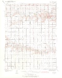
1939 Map of Pence
USGS Topo · Published 1971About this map
A high plains landscape defined by the intersection of three counties—Logan, Wichita, and Scott—emerges in this 1939 survey. The terrain is deeply incised by the drainage systems of Chalk Creek and Ladder Creek, which provide the primary geographical relief across the townships of Paxton and Beaver. The settlement pattern is markedly rural, characterized by a grid of section lines and a distributed network of one-room schools that served the isolated farming families of the pre-war era.
Find a feature on this map
22 named features on this map. Tap any name to fly to it.
Don’t see what you’re looking for? This feature index may not catch every label — zoom into the map to look around manually.
Map Details
Editions of this 1939 Pence Map
2 editions found
Other maps of this area

1939 · Lake Mc Bride
USGS Topo · 1:24,000

1939 · Sandon
USGS Topo · 1:62,500

1939 · Pence
USGS Topo · 1:62,500

1940 · Scott City
USGS Topo · 1:62,500

1941 · Modoc
USGS Topo · 1:62,500

1941 · Pence
USGS Topo · 1:62,500

1942 · Sandon
USGS Topo · 1:62,500

1942 · Lake Mc Bride
USGS Topo · 1:31,680

1951 · Scott City
USGS Topo · 1:62,500

1951 · Modoc
USGS Topo · 1:62,500