
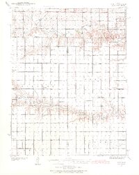
1939 Map of Pence
USGS Topo · Published 1971About this map
Ladder Creek and Chalk Creek carve distinct east-west drainages across this section of the High Plains, defining the rural character of western Kansas at the end of the 1930s. The landscape is organized into a rigid township grid, where the boundaries of Paxton, Beaver, Isabel, and Elton meet at the intersection of Logan, Wichita, and Scott counties. This survey reveals a remarkably high density of rural schoolhouses, suggesting a decentralized but active farming population before the mid-century trend toward school consolidation.
Find a feature on this map
18 named features on this map. Tap any name to fly to it.
Don’t see what you’re looking for? This feature index may not catch every label — zoom into the map to look around manually.
Map Details
Editions of this 1939 Pence Map
2 editions found
Other maps of this area

1939 · Lake Mc Bride
USGS Topo · 1:24,000

1939 · Sandon
USGS Topo · 1:62,500

1940 · Scott City
USGS Topo · 1:62,500

1941 · Modoc
USGS Topo · 1:62,500

1941 · Pence
USGS Topo · 1:62,500

1942 · Sandon
USGS Topo · 1:62,500

1942 · Lake Mc Bride
USGS Topo · 1:31,680

1951 · Scott City
USGS Topo · 1:62,500

1951 · Modoc
USGS Topo · 1:62,500

1955 · Scott City
USGS Topo · 1:250,000