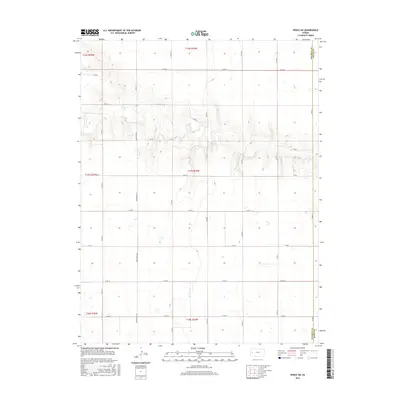
2015 Map of Pence SW
USGS Topo · Published 2015About this map
Marienthal Rd serves as a primary north-south artery through this portion of western Kansas, where the landscape is defined by the high plains of Wichita Co and Scott Co. The map reveals a strictly organized grid of rural infrastructure, from Co Rd G in the north to Co Rd N in the south, reflecting the systematic land division of the Public Land Survey System. The terrain is characterized by the subtle drainage patterns that break the plateau, particularly evident in the winding contours between Co Rd H and Co Rd I. This area represents the open agricultural and ranching environment of the region, where the primary human footprint consists of the straight-line section roads and scattered windmills or storage tanks required for life in the High Plains. It is a portrait of a landscape governed by the township and range system, showing the boundaries of t17s r35w and surrounding districts.
Find a feature on this map
59 named features on this map. Tap any name to fly to it.
Don’t see what you’re looking for? This feature index may not catch every label — zoom into the map to look around manually.
Map Details
Editions of this 2015 Pence SW Map
This is the sole edition of this map. No revisions or reprints were ever made.
Other maps of this area

1939 · Pence
USGS Topo · 1:62,500

1941 · Modoc
USGS Topo · 1:62,500

1941 · Pence
USGS Topo · 1:62,500

1951 · Modoc
USGS Topo · 1:62,500

1955 · Scott City
USGS Topo · 1:250,000

1958 · Scott City
USGS Topo · 1:250,000

1968 · Russell Springs 3 SE
USGS Topo · 1:24,000

1968 · Russell Springs 3 NE
USGS Topo · 1:24,000

1970 · Leoti
USGS Topo · 1:24,000
1976 · Pence
USGS Topo · 1:24,000